Watches Issued For Baltimore, Isaias Update
A Flash Flood Watch is in effect from 11pm Monday to 11pm Tuesday. A Tropical Storm Watch is in effect until further notice.
MINYANCAST BULLETIN
August 2 // 5:45pm
HURRICANE & WEATHER UPDATE
ISAIAS TO BRING GUSTY WINDS AND EXTREME FLASH FLOODING UP THE EAST COAST THROUGH MID-WEEK
Information current as of 5pm
OVERVIEW
Winds: 70 mph Movement: WNW at 9 mph Watch/Warning: Tropical Storm & Flash Flood Watches
Impact: Flooding and power outages possible
DISCUSSION
The center of Tropical Storm Isaias is located only 65 miles southeast of Cape Canaveral, Florida. Winds are at 70 mph as the storm moves north-northwest at 9 mph. Some fluctuations in strength are possible, and Isaias could become a hurricane overnight.
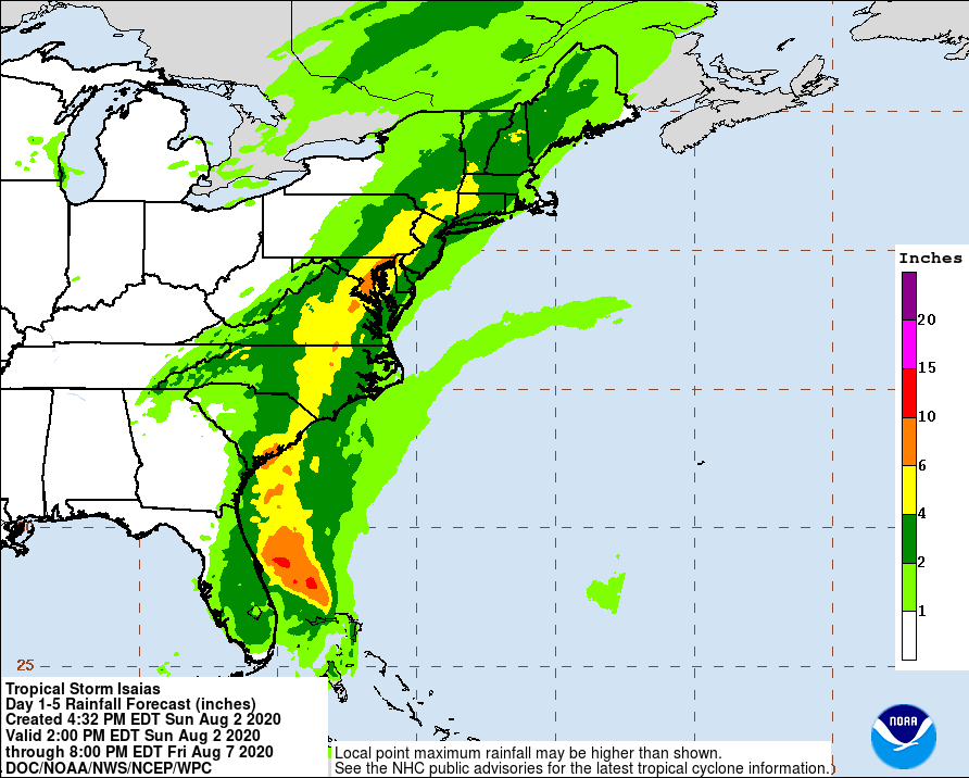
Regardless, very heavy rains threaten the entirety of the United States east coast. At least two inches of rain are expected from Florida north to Maine.
Locally, 3 to 6 inches are expected. This will occur Monday night and Tuesday.
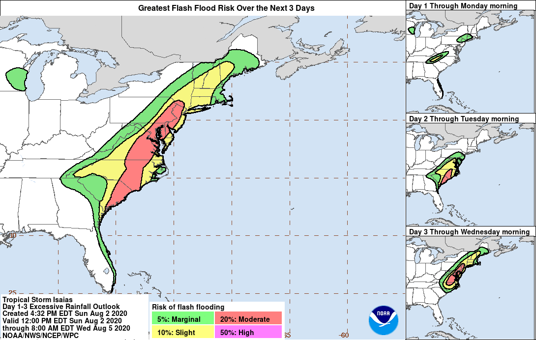
A Flash Flood Watch has been issued for 11pm Monday until 11pm Tuesday, as flash flooding is expected from Isaias. The NWS said there is the “Potential for major flooding rain” and that “Emergency plans should include the potential for major flooding from heavy rain. Evacuations and rescues are likely” across the region.
A Tropical Storm Watch is now in effect for the potential for winds of 39 mph to 58 mph. This could cause tree limbs to fall, and cause scattered power outages. This is especially true when combined with saturated soils, which could lead to downed trees.
The ‘situation overview’ provided by the NWS says the following:
“Significant flash flooding of small streams and creeks is possible Monday night into Tuesday evening as rainfall associated with Tropical Storm Isaias spreads northward. Widespread rainfall totals of 3 to 6 inches are expected with locally higher amounts possible. The highest amounts are expected east of the Blue Ridge Mountains particularly over the I-95 corridor late Monday night through Tuesday. Moderate coastal flooding is also possible at times of high tide Tuesday as Isaias makes its closest approach to the area. Minor wind damage and scattered power outages are also possible especially across southern Maryland.”
The Weather Prediction Center (WPC) has placed the area under a “Moderate” risk category for flash flooding.
For updates to this situation, please see advisories issued by the National Hurricane Center at hurricanes.gov. Local weather updates can be seen at weather.gov/lwx. For information on preparing for a hurricane, visit ready.gov/hurricane
STAY SAFE AND STAY DRY!
Comments
Post a Comment
Leave a comment for us here...