What Will This Winter Be Like?
This article will cover 4 different winter outlooks to give you an idea of what might happen this winter.
Important to remember is that these are all educated guesses, and a few miles can make a big difference in a storm setup.
NOAA OUTLOOK
The NOAA outlook, published on October 15, favors warmer than average temperatures this winter in our region. Keep in mind, they were correct last year.
They give equal chances of above, near, and below average precipitation.
"More modest probabilities for warmer temperatures are forecast in the southern parts of the west coast, and from the Mid-Atlantic into the Northeast.
"The remainder of the U.S., including the Mid-Atlantic and Northeast, falls into the category of equal chances for below-, near-, or above-average precipitation."
Summary: Warm, precipitation could be anything.
FARMERS' ALMANAC
They are a bit ambitious with the snow this winter, going so far as to say the following:
"Remember last year’s almost snow-free winter in the Northeast? Well, this year our prediction is very different, with the possibility of a blizzard hitting the Mid-Atlantic and Northeast states during the second week of February. This storm may bring up to 1-2 feet of snow to cities from Washington, D.C. to Boston, Massachusetts!"
"And for those living in the eastern half of the country, you may get clobbered during the final week of March, but what falls from the sky will depend on where you live—this storm will track from the nation’s midsection to central New England and bring a significant late-season snowfall to the north of its track, and showers and thunderstorms to the south."
Summary: Cold, wet, and snowy overall
OLD FARMERS' ALMANAC
This is a totally separate almanac, but also started over 200 years ago.
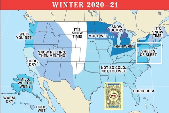
They predict that "below-normal average temperatures limited to the western portion of the nation", and the east will be warmer than average.
"On the precipitation side of things, expect “wet” to be a wintertime constant, with rain or average to below-average snowfall to be the standard throughout most of the country.
"Specifically, precipitation will be below normal from Delmarva into North Carolina", the forecast says.
Their summary states that there will be "sheets of sleet", possibly indicating lots of storms near but above freezing, bringing ice and cold rain.
One of the biggest factors this year is La Nina, which "is a natural ocean-atmospheric phenomenon marked by cooler-than-average sea surface temperatures across the central and eastern Pacific Ocean near the equator, the opposite of El Nino (“little boy”) which features warmer-than-average sea surface temperatures in that region."
In September, the NOAA reported that "scientists say there is a 75% chance that La Nina will be in place from December 2020 through February 2021."
According to the report, "La Nina typically brings above-average precipitation and colder-than-average temperatures along the northern tier of the U.S., along with below-average precipitation and above-average temperatures across the South."
According to Justin Weather, there have been 20 La Nina winters from 1950 - 2017. Out of those, 5 have been strong, 6 were moderate and 9 were weak.
In the weak years, 55% had below-average temperatures but 88% had below-average snowfall. 66% of moderate years had below average temperatures and below-average snowfall occurred 83% of the time. In strong La Nina years, 80% were above-average in temperatures, and 80% were below-average in snowfall.
Overall, "If you don’t want snow, La Nina historically has been your friend", the report says.
We often end up at the borderline of La Nina positioning, and commonly just miss the snow.
Accuweather meteorologist Paul Pastelok says that "“An early-season chill is expected in the Great Lakes, Ohio Valley into the Northeast.” This will be followed by a warmer mid-winter, before colder conditions return.
"“A big turn" is expected around the middle of the season as temperatures are predicted to rise and snowfall should decrease, Pastelok said, due in part to the strength and positioning of the polar vortex."
But they expect snow to be below-average overall.


Comments
Post a Comment
Leave a comment for us here...