Delta Emerging Into Southern Gulf // Local Impacts?
"Satellite and surface observations show that Delta made landfall
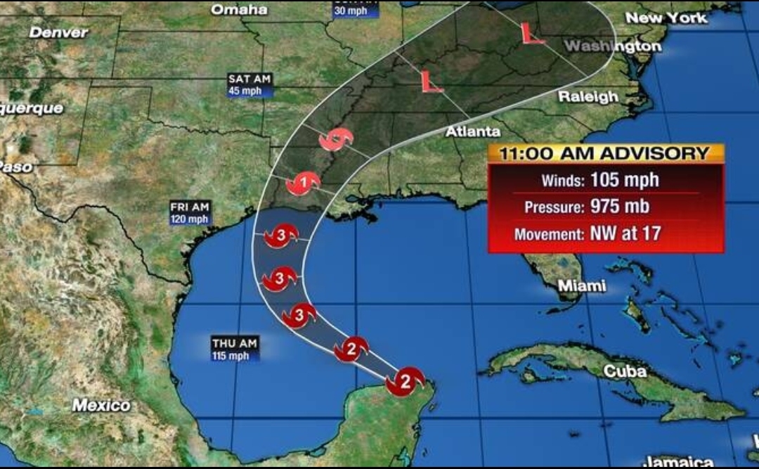


along the northeastern coast of the Yucatan peninsula around 1030
UTC [6:30 am] near Puerto Morelos", National Hurricane Center Forecaster Brown said late this morning.
"Since landfall, Delta has moved across the northeastern portion of the Yucatan peninsula and is now about the emerge off the northern coast of the peninsula into the
southern Gulf of Mexico."
Delta should strengthen over the Gulf in the next 36 hours, but some weakening is expected in the final hours before landfall in Western Louisiana.
"Once Delta moves over the southern Gulf of Mexico, warm waters and
expected low vertical wind shear conditions are expected to allow
for re-strengthening during the next 24 to 36 hours", Brown said.
"After 48 hours, increasing southwesterly shear and cooler waters over the northern Gulf are likely to induce some weakening. The intensity guidance has trended downward this cycle, and the NHC forecast has been adjusted accordingly. Delta, however is still expected to regain major hurricane status and the wind field is likely to grow in size during its approach to the northern Gulf coast, which will
increase the storm surge and wind threats.
"Regardless of Delta's
landfall intensity, life-threatening storm surge and strong winds
are likely over a large portion of the northwestern and northern
Gulf coast, which has necessitated the issuance of Storm Surge,
Hurricane, and Tropical Storm watches for portions of that area", according to the NHC.
Several inches of rain are expected along the northern Gulf coast. This is in addition to storm surges of around 10 feet and very high winds.

The most likely point of landfall has shifted to be in Western Louisiana, not far from where Hurricane Laura came inland.
Local affects are likely, but the exact timing and level of impact is still uncertain. It looks that it would most likely be on Sunday, into Monday, with a few showers likely. There could be some heavy rainfall.
Local affects are likely, but the exact timing and level of impact is still uncertain. It looks that it would most likely be on Sunday, into Monday, with a few showers likely. There could be some heavy rainfall.
As the National Weather Service put it, "Uncertainty continues to be the theme of the extended forecast due to the remnants of Delta."
A more exact track and better details will emerge over the next few days.
Comments
Post a Comment
Leave a comment for us here...