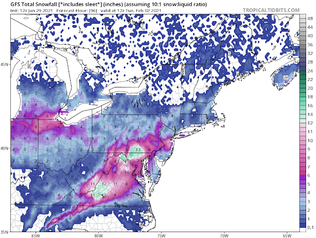
Updated Snow Forecast For Sunday-Monday
It is becoming more certain that we will get at least some moderate affects from this upcoming snowstorm. Here is an updated outlook on this developing winter storm.
BREAKING: WINTER STORM WATCH IN EFFECT 6AM SUNDAY - 6AM MONDAY
Snow should begin by mid-morning Sunday, and continue during the day. It could mix with or become a sleet/freezing rain combination Sunday night. This could be on the lighter side due to drier air moving in.
Precipitation is expected to change back to snow Monday mid-morning, continuing during the day.
Snowfall totals of 3 to 5 inches appear likely for Sunday. Assuming drier air moves in Sunday night, a trace of ice and a coating of sleet/snow is possible. If freezing rain does occur, then it would likely melt down some of the snow from Sunday (1).
Given a moderate storm Monday, as the new low pressure system forms over the coast, we could see another 2 to 4 inches of snow. That brings the total to 5-9 inches. If that low strengthens more rapidly and intensely, then it could be 4 to 7 inches for a grand total of 7-12 inches.
Three scenarios:
1. Snow Sunday, snow/sleet Sunday night, snow Monday: totals accumulations of 7-10 inches
2. Snow Sunday, mix Sunday night, snow Monday, weaker coastal low: totals Sunday of 3-5", trace of ice, and new snow accumulations of 2-4" Monday
3. Snow Sunday, mixing Sunday night then heavy snow Monday with a stronger low: totals Sunday of 3-5", trace of ice, and new snow Monday of 4-7"
To give you some opinions, the National Weather Service is predicting 3-4 inches through Sunday night. Accuweather says we will get 3 to 6 inches through Monday. Both agree we will get a trace of ice.
Below are the Canadian model's predictions:
(Top to bottom: 1pm Sunday, 7am Monday, 7pm Monday)
Below are the NAM 12km model predictions, for the same hours;
The GEM predicts 5-6 inches, with the Nam having 7 inches. These are both reasonable, although assuming the low does strengthen well and we aren't watered down by freezing rain/drizzle.
Our Forecast?
MinyanCast predicts that we will get the following:
Sunday: 3-5"
Sunday night: Trace of ice, coating of snow
Monday: 2-4"
There is a potential for much more snow, especially Monday; there is also a possibility of it busting on us, and we get only a few inches that are melted away.
We will know more after Shabbos, as that will be only 12 hours from the start of wintry weather, and within about 48 hours of the end of it.
(1) In the past two winter weather events (December 16-December 17 2020 & January 25-January 26 2021), the freezing rain caused snow totals to go down by about 1/2 (from 4" to 2" & 1" to 0.5" respectively).


Comments
Post a Comment
Leave a comment for us here...