Winter Outlook 2022-2023
Everyone has been wondering when we will finally get a big blizzard, or when we will finally see more than a foot of snow that doesn't immediately melt.


Will this be that winter that brings significant snowfall?
MinyanCast is proud to once again release a winter outlook, predicting the temperatures and snowfall for the upcoming 2022-2023 winter season.

Released: Wednesday, October 19 2022
Discussion
First, here is an overview of what the winter as a whole will bring, both in the atmosphere and its potential impact on the ground.
La Niña
We are headed for what is called La Niña, when the waters in the Pacific are cooler, for the third winter in a row. This is called a triple dip, something which has only happened a few times in the past 75 years.
The La Niña comes with cooler water temperatures in the Pacific Ocean, which is generally reflected by warmer than average temperatures along the United States East Coast.
Nevertheless, a few shots of colder air can be expected like by every winter, in which temperatures are in the upper 20s or low 30s.
Polar Vortex
The key to a serious plunge of cold air lies in the polar vortex. This vortex, when it is strong, bottles up the Arctic air up north, typically in Canada.
While it is nearly impossible to accurately the exact position of the polar vortex at any given point in the winter, the vortex often weakens and drops downwards into the US. Areas in the Upper Midwest frequently see temperatures near or below zero as a result.
The question becomes, will this vortex slide south and east in our direction, bringing a blast of arctic air?
SSW And The Polar Vortex
For the upcoming winter, as mentioned, will be a La Niña winter; scientists at the NOAA give a 91% chance of a La Niña. La Niña winters have a strong connection to an event called a Sudden Stratospheric Warming, or SSW. An SSW, without getting detailed, is when the part of the atmosphere called the Stratosphere rapidly warms. It can warm by as much as 120 degrees Fahrenheit, with the warming taking place between 6 and 30 miles up in the atmosphere. It typically cools off after a week or two.
Winters with a La Niña have historically brought a 60-75% chance of an SSW. It also typically happens somewhat later in the winter. One factor impacted by an SSW is the Polar Vortex. An SSW usually causes the vortex to weaken and thereby bring cold and snowy weather to the East Coast of the US.
The graphic below shows the quantity of SSWs per month for an El Nino (cooler Pacific) and La Niña (warmer Pacific).

An SSW typically will cause an area of high pressure to be stuck up north, usually in or around Greenland. This area of high pressure pulls cold air from the Arctic down into the US. It also causes low pressure, which can bring snow, to remain south in the US and not pass north of the region.
The Catch
The catch with all of this lies in small scale and last minute weather patterns. Depending on the exact scale and position of the SSW, blocking high pressure and other weather details, the La Niña and SSW is not guaranteed to bring a strong cold blast or significant snow.
Summary
At the end of the day, many factors in the upcoming winter show that a cold blast is likely in January, along with a period of heightened snow activity. The exact extent is difficult to determine until right before any specific storm occurs.
Predictions
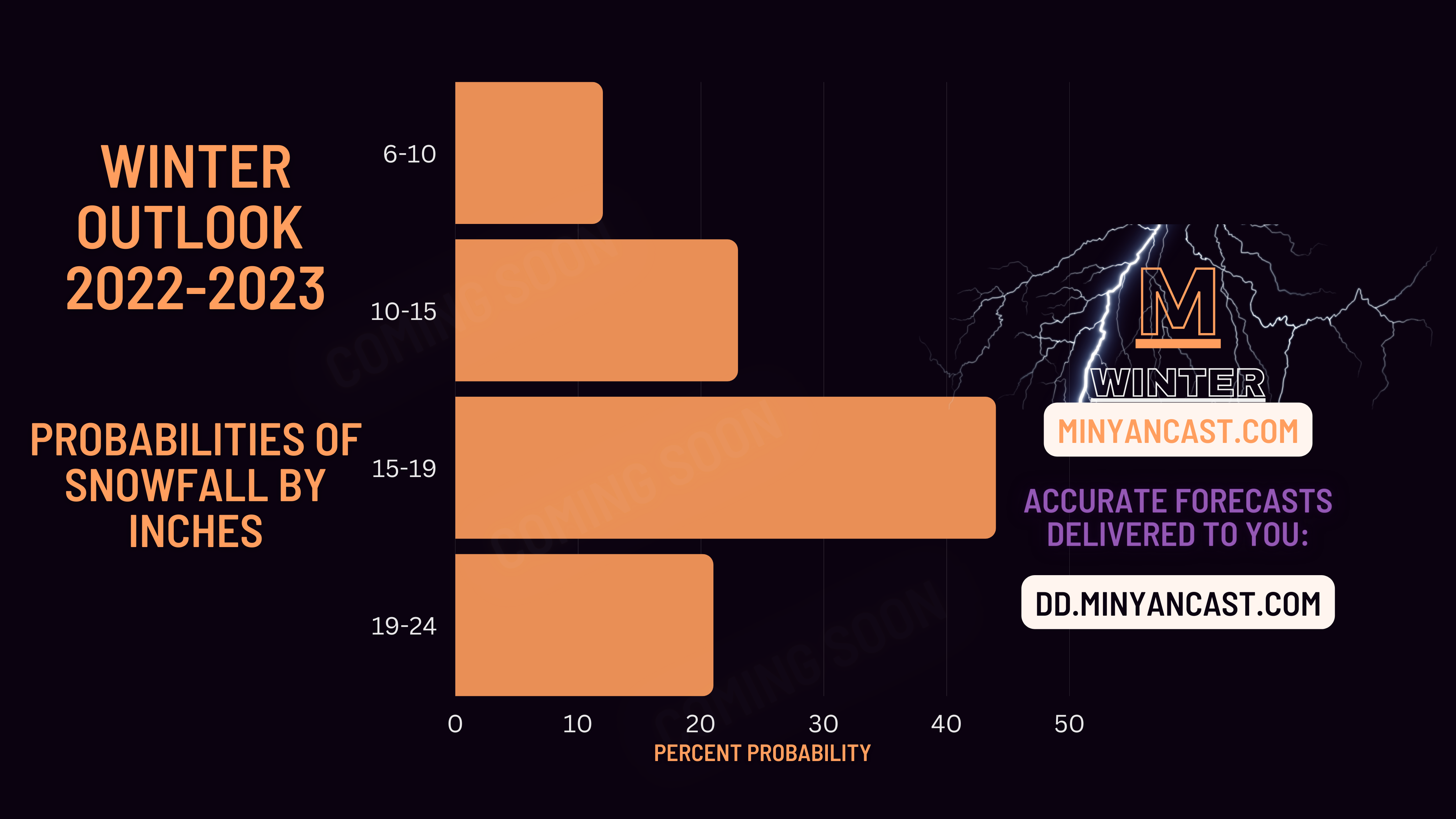
MinyanCast predicts the following to occur in the upcoming winter months, December through March.
Snowfall: 15 to 19 inches (exact number: 17 inches)
Ice: 0.4 to 0.6 inches (exact number: 0.5)


Below is a breakdown of each month.
December: The month may have a brief cooldown but will otherwise be relatively mild. Don't expect much snow.
January: This will be the most active month. Expect several snowstorms, mainly at the beginning and end portions of the month. A cold blast is likely as well, especially in the middle of the month.
February: While the winter won't have disappeared, activity will be winding down. We predict additional snow in the beginning of the month before temperatures moderate a bit. A small snowstorm could impact late in the month with a dip in temperature.
Atmospheric indications and computer predictions show the La Niña is likely to end sometime around March, which should result in an end to any winter activity.
In a high end scenario, the various pieces in the atmospheric puzzle (the SSW, blocking high pressure, moisture, temperature, etc) would line up almost perfectly, causing multiple snowstorms within a week or so, bringing 12 to 18 inches or more just in that timeframe.
On the flipside, if the SSW doesn't happen or doesn't match up with other factors, we only get a couple of snowstorms in the whole winter, with a total of 10 inches or something closer to that.
About MinyanCast
MinyanCast is a local weather forecast service, started in January 2021, which provides accurate forecasts and information for the community. Its accuracy stems from it being run by actual humans who are local and know the Baltimore nuances.
MinyanCast issues forecasts daily on its website, which has received over 103,000 views, and sends them over Whatsapp and email.
To join our Whatsapp group, use this link: WA.minyancast.com.
To join the email list, please go here: de.minyancast.com.
To learn more about MinyanCast or if you have any questions about this outlook, please do not hesitate to reach out to info@minyancast.com.